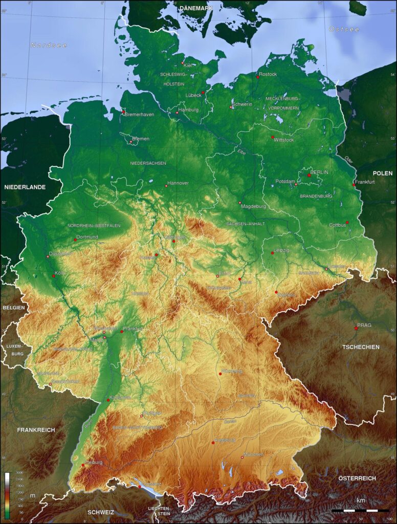
Germany, a nation synonymous with historical significance and cultural vibrancy, boasts a captivating geography that shapes its identity. Its diverse landscapes, ranging from the majestic peaks of the Alps to the flat expanses of the North German Plain, offer a unique tapestry of natural wonders. Let’s delve into the geographical heart of Germany, exploring its defining features and the rich tapestry it creates.

A Nation Defined by Three Distinct Regions
Germany’s topography can be broadly categorized into three distinct regions, each offering a distinct character:
- The North German Plain: Stretching from the Danish border to the Central Uplands, this vast, low-lying region is characterized by fertile farmlands, dotted with charming villages and historic towns. The North Sea and Baltic Sea coastlines add a maritime touch, with popular beach resorts and port cities like Hamburg and Rostock.
- The Central German Uplands: This central zone, encompassing the Rhine Massif, the Harz Mountains, and the Thuringian Forest, presents a more elevated terrain. Dense forests, rolling hills, and picturesque valleys dominate this region, offering a haven for outdoor enthusiasts and nature lovers.
- The Southern German Highlands: As the name suggests, this southern region is dominated by the majestic peaks of the Bavarian Alps. The Zugspitze, Germany’s highest point at 2,962 meters, stands as a crowning jewel, attracting mountaineers and winter sports enthusiasts. Picturesque valleys, glacial lakes, and charming villages nestled amidst the mountains create a postcard-perfect landscape.
Beyond the Mountains and Plains: A Diverse Tapestry
Germany’s geographical tapestry extends beyond these three major regions. The Rhine River, a vital waterway snaking through the country’s heart, has played a significant role in shaping its history and culture. Its fertile valleys and picturesque towns like Heidelberg and Cologne continue to be major tourist draws.
Furthermore, numerous rivers, including the Elbe, Danube, and Weser, crisscross the country, adding to its diverse hydrological network. These waterways have historically served as transportation routes and centers of trade, contributing to the nation’s economic development.
Statistics that Paint a Picture
- Total Area: 357,021 square kilometers (137,847 square miles), making it the 7th largest country in Europe and 63rd in the world.
- Highest Point: Zugspitze, at 2,962 meters (9,718 feet).
- Coastline: 2,389 kilometers (1,484 miles).
- Major Rivers: Rhine (1,233 km), Elbe (1,094 km), Danube (688 km).
A Landscape Shaped by Geological Forces
Germany’s diverse landscape is a product of millions of years of geological activity. The Central Uplands, for instance, were formed by ancient mountain ranges that have weathered over time. The North German Plain, on the other hand, is a result of glacial deposits left behind during the Ice Age. The dramatic landscapes of the Alps are a testament to the ongoing processes of plate tectonics, constantly reshaping the region.
A Hub for Biodiversity and Natural Beauty
Germany’s diverse geography fosters a rich tapestry of flora and fauna. From the lush forests of the Central Uplands to the alpine meadows of the Bavarian Alps, a multitude of ecosystems provide habitat for a wide range of species. National parks, like the Bavarian Forest National Park and the Wadden Sea National Park, are dedicated to protecting this natural heritage.
Germany’s geography is not merely a backdrop; it is an integral part of the nation’s identity. From the fertile plains that sustain its agricultural heartland to the soaring peaks that inspire awe, the landscape has shaped its history, culture, and economic development. As you explore Germany, remember that its diverse geography offers a unique blend of natural beauty and cultural richness, waiting to be discovered.